Saturday, October 30, 2010

Constructed Territory

An exhibit opening tomorrow at the Robert & Elaine Stein Galleries at Wright State University, in Dayton, Ohio:

Constructed Territory

October 31, 2010–January 9, 2011
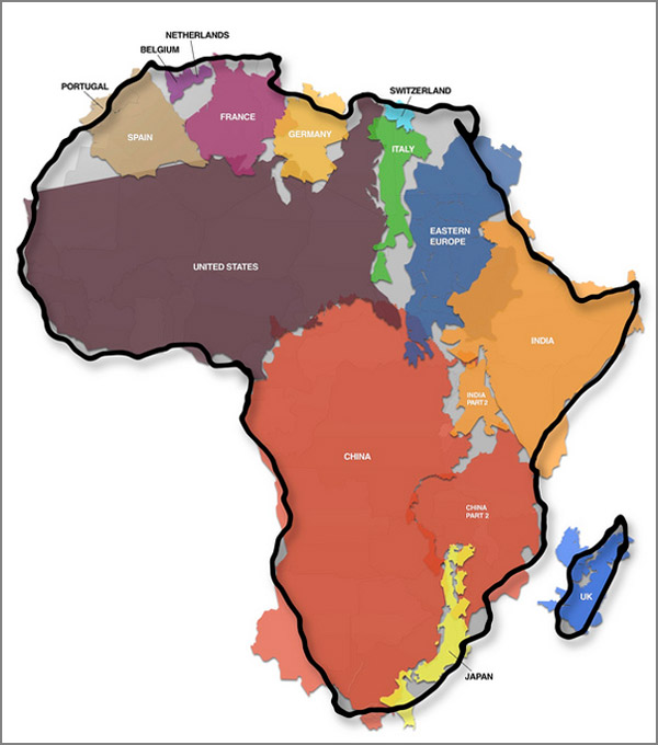
Constructed Territory presents a variety of contemporary artists who incorporate maps, cartography, and topographical examination into their work. This exhibition investigates geographical concepts from a range of perspectives to promote themes of exploration, navigation and the representation of physical space. Assistant Professor of Art Tracy Longley-Cook curated the exhibition.

This exhibit will feature 32 artists working in photography, digital and mixed media, sculpture, drawing, printmaking and book arts. As a system of diagramed information, maps define locations, orient the viewer, graph terrain, and delineate borders. Maps traditionally present regions of space, which are transformed into condensed descriptive visual references. Borrowing from the universal language of maps and cartographic techniques, the artists in Constructed Territory examine and redefine the established conventions of our understanding and connection to place.
More information

Labels: , ,

Friday, October 29, 2010

Europe Map In Lego Kinda More Awesome Than Original

From Thatsaabguy:

Who doesn't love Lego? If you don't, you're some kind of commie freak or something. How about a gigantic floor map of Europe, made entirely of Lego?


Thanks to our friends at gizmondo.com, we can bask in the glory of almost 300k bricks laid out in a lovely topo map of the European continent. Even big cities get represented, like Brussels...


HT to Jim, thanks buddy!

#695

Labels: ,

Wednesday, October 27, 2010

Movie Nation

Online Carto-Cine-phile, subtonix, has created a map of the United States with each state renamed for a film that mentions it in the title, or uses that state for its locale.


Some of these make sense. Robocop takes place in a future Detroit. Raising Arizona... But Gummo for Ohio? Never heard of it.

Also possible errors... Fargo is in North Dakota. However, I haven't seen that film. Does some of the action take place across the border in Minnesota?

Can you suggest a better film for your state?

Via The Huffington Post

Labels:

Tuesday, October 26, 2010

Instant Transporter

From Thatsaabguy:

ALERT: The link I'm about to reveal to you has been shown to cause loss of productivity, destruction of ample free time, and serious scorn from employers/spouses/schedules everywhere. You have been warned.

This is by far the best and most interesting use I've yet seen for Google Street View. Click on this linky link:

http://web.mit.edu/~jmcmicha/www/globegenie/

and be transported instantly anywhere in the world the Google photo trucks have thus far traveled. Odds are good you'll end up somewhere in the continental United States, as this is where the majority of Street View images have been taken so far, but all seven continents are represented.

It's hard to get an image of the page, so I'll leave it to your imagination...until you hit that link, that is, and find yourself on some lonesome road in the middle of nowhere. Repeatedly. For hours on end. Forgetting to bathe, go to work, or move rooted from your seat in fascination. Hey, don't say I didn't warn ya...

Labels: ,

Monday, October 25, 2010

St. Crispin's Day

"We few, we happy few, we band of brothers."

Today is Saint Crispin's Day:


Shakespeare wrote this rousing speech for King Henry V prior to the Battle of Agincourt, where a small but plucky English army dealt a severe defeat to a much larger French force.


The battle is notable for the use of the English longbow, which played no small part in the victory.


Popular legend states that the origin of the use of the middle finger as an insult dates from this battle. The English archers could still "pluck" the yew bow, in spite of losing their fingers. Snopes clarifies that this is not true.

Labels: , , ,

Sunday, October 24, 2010

Song of Ice and Fire

J.E. Fullerton has created beautiful maps depicting places in George R.R. Martin's series of Fantasy books, The Song of Ice and Fire. The maps employ a medieval style, including heraldry.


This map depicts a region of Westros known as the Trident (because three rivers come together here). Many key events of the most recent book in the series, A Feast for Crows take place her.

Via The Map Room

Labels: ,

Wednesday, October 20, 2010

Web 2.0 World

No doubt inspired by the xkcd comic Online Communities (updated recently as Online Communities 2), the folks at the Web 2.0 Summit have created/updated their interactive Web 2.0 Points of Control Map:

More than any time in the history of the Web, incumbents in the network economy are consolidating their power and staking new claims to key points of control.
Pan and zoom to explore the map.

HT to Matt

#690


Labels:

Monday, October 18, 2010

How big IS Africa?

From Thatsaabguy:

Have you ever been to Africa? It's a big, BIG place. How big? This big:


Courtesy of our friends at Boing Boing.

The World in Your Morning Coffee

Happy Monday morning. Time for some coffee!

Coffee art, previously on Cartophilia here and here.

From My Food Looks Funny

Labels: , ,

Friday, October 15, 2010

Which Way Does Your Door Swing?

From Thatsaabguy:

I'm going to start this blog off by saying that the viewpoints expressed herein are strictly mine, and in no way reflect the views of management - unless, of course, Cartophiliac agrees with me. I would also like to request that your comments and replies to this post remain civil at all times.

THAT outta get your attention.

Here it goes: the last few weeks/months/years have seen a massive upheaval of human rights discussions in our country, no longer centered on race but on sexual orientation. Many states now allow gay and lesbian couples to marry - a practice that I completely support and for the life of me cannot understand why anyone in their right mind would not. (If you're suggesting that gay marriage somehow destroys straight marriage, then why not try to abolish divorce??) And what's with the sudden rash of gay-bashing and bullying in our high schools?

The online dating site OK Cupid recently conducted a survey of over 4 million members, and came up with some hard, fast numbers "so that people might make better choices about what they say, think, and do." These numbers go a LONG way towards debunking the fear-mongering screaming about homosexuality - gay people are not interested in straights, are not promiscuous, are slightly more intelligent overall, and much more.

Where's this relate to maps, you say? How about right here:

I'm just going to let those colors speak for themselves. No, wait - here's a 2008 electoral map, that might well clear some of this up:


Full disclosure: I am not gay, nor do I have any hidden political agenda outside simple Common Sense. I live in the Seattle area, and the culture shock after moving here from southwest Ohio was immense. Nowhere have I ever lived (outside Norway) have folks been so accepting and supportive of "alternate lifestyles". Our cousins north of the border are even more so, and this map may well explain why.

I'll just let those colors speak for themselves. You, however, really should read the full survey results, posted right here. They are fascinating in every possible way, and should provide ready fuel to anyone forced to combat a bigot in a duel of wits, facts and numbers (not that these things ever helped win said arguments, of course...)

Come on, people - can't we all just get along??

Labels: ,

Hot Hungarian

Occupying a prominent location in the Cartophiliac kitchen is the Szeged Hungarian Hot Paprika. Good stuff, not only because it features a map on the tin!

But wait, there's more! The map of Hungary, in three regions, looks like a sideways flag of Hungary!

Can any Hungarian carto-fans out there tell me if the tri-colored regions on the tin represent three distinct regions in the country?

Vexillophiles note: Michael5000 gives the flag of Hungary an "A" in his latest Flag Friday post.

(I'm also hoping the title "Hot Hungarian" will help me get more hits from web surfers....)


[Cross-posted to Vexillophilia]

Labels: , ,

Wednesday, October 13, 2010

Badges? We Need Mappin' Badges!

The Boy Scouts of America have announced a new, map related, merit badge: Geocaching!

According to the "Official Blog of Scouting Magazine", here are a few highlights of what Scouts will learn while earning the Geocaching merit badge:
  • Precautions necessary to have a safe time while searching for geocaches
  • Geocaching etiquette and how the principles of Leave No Trace apply
  • Geocaching terms
  • How GPS technology works
  • Steps for finding and logging a cache
  • How to use geocaching.com, the official online home of geocaching
Of course, the best thing about this new merit badge is that it has a map right there on the badge! A quick check revealed several other badges with maps:

Space Exploration
Geology
Citizenship in the World
Not to be outdone by the boys, the Girl Scouts of America also offer a badge with a map, "Girl Scouting in My Future"

Via The Map Room

#685


Labels: ,

Monday, October 11, 2010

The Man in the High Castle

The Man in the High Castle, by Philip K. Dick, is considered a classic of alternate history fiction. This Hugo Award winning novel is set in a world where the Allies lost World War II; dominated by Nazi Germany, Imperial Japan, and the other pro-fascist nations.

The Guardian reports that Ridley Scott is preparing a BBC miniseries based on the novel. Earlier in his career, Scott had great success adapting Dick's novel of a robotic future, Do Androids Dream of Electric Sheep?, as the film Blade Runner.

To get map lovers in the mood, io9.com offers this map of the world after the fall:


While I always appreciate any attempt to create maps of alternate futures, I found this map maker to be a bit lazy... What? Did Italy fill in the Mediterranean Sea, just so their empire would look bigger?

More Alternate History maps on Cartophilia

HT to Josh Calder

UPDATE: OK, I'm an idiot. Thanks to Ben for pointing out that yes, the Nazis DO actually drain the Mediterranean Sea in this book. I'm a big fan of alternate history, but this is one I haven't read yet. I will correct that deficiency.

Labels: ,

Wednesday, October 6, 2010

Online Geography 2010

The UberGeek web comic, xkcd, has updated its map of online communities from 2007:


Click image to see hi-res


Online geography changes much more quickly that earthly geography.

Where is Cartophilia in all this? Somewhere in the Miscellanea I suppose...


Other xkcd maps featured on Cartophilia

HT to BillWendel

Labels: , ,

Tuesday, October 5, 2010

T-Shirt Tuesday: Take Me To Your Loser

"Citizens of Earth! Please, do not be afraid!"

Globish map goodness from The Onion


Labels: ,

Monday, October 4, 2010

CartoYoga

The art of yoga originated in Asia. So, where better to practice yoga than on a map of Asia?


Thanks to Josie for sharing her photo.

Speaking of yoga and maps, here is a clever use of a map of Australia in a yoga logo (say that three times real fast...):


Via Bored Panda

More Australian map inspired logos can be found here.

Labels: , , ,

Saturday, October 2, 2010

Gerrymandering

Last week, the New York Times offered a look at some of the worst Gerrymandered congressional districts in the United States. In most states, districts are drawn by members of the political party that controls the state legislature. The result is that "safe" districts are created for representatives; often drawn to include certain types of voters. The Illinois District 17, below, was drawn to include precincts that primarily vote Democratic, to insure that the Democratic incumbent will be re-elected.


After the 2000 Census, when Ohio had to lose a couple seats in Congress, Republicans carefully drew the lines of the 3rd and 8th Districts to dilute the votes of primarily Democratic Dayton, and ensure the election of Mike Turner in the 3rd, and re-election of John Boehner in the 8th.


The preliminary results of the 2010 Census indicate that Ohio will lose one or two more seats in Congress. The November state legislature elections will likely determine the fate of congressional districts in Ohio and many other states.

Via The Map Room

#680

Labels: , ,