Saturday, September 3, 2011

Human Cannonball

I suppose this is only tangentially about maps... but here goes.

I started the evening last night at Riverscape, Dayton's excellent downtown outdoor music venue. Enjoyed listening to a local band, Human Cannonball. Not only did I enjoy the music, but two other geeky things caught my eye... A map t-shirt:


I'm not sure what the shirt is saying... First Ohio, then the world? Also during the show, this guy played his homemade Theremin!


To give this band an additional plug, here is a video from The Dayton Informer with an excerpt from the show...


... and a classic duck joke. I'm going to be sorry to see this summer end.

Labels: , , , ,

Friday, July 8, 2011

Inflated Stereotypes

The latest from Christoph Niemann: THE WORLD MAP OF USELESS STEREOTYPES


Labels: ,

Tuesday, April 26, 2011

Carto-Vexillo-philic tattoo

Moments ago, I posted this on my Flag Fan blog, Vexillophilia. But then (to my horror) I took a closer look at the photo and saw that he also has maps tattooed on his belly!


Time to wash my eyes.

Labels: , ,

Tuesday, April 19, 2011

Pit Stop Mug

It's not as if CBS needs me to promote their shows or help sell their stuff... but The Amazing Race is my second favorite reality TV show, and this is a sweet mug...


The Amazing Race Pit Stop Mug

Labels: ,

Friday, February 4, 2011

Quadrilateral World

Carto-friend Gail sends this geometric map created by her son, Murphy:

Murphy had to do an assignment for Geometry to create an “artistic image” using only quadrilaterals. He drew a map of the world using eight quadrilaterals: irregular quadrilaterals, kites, parallelograms, rectangles, squares, trapezoids, isosceles trapezoids, and rhombuses. I thought you might share my appreciation for his final product.

Thanks, Murphy and Gail. Some people think my love of maps is "square". You have proved otherwise.


#725

Labels:

Tuesday, January 25, 2011

Must Be the Equivalencia-Area Projection

funny food photos - Peel the World
see more My Food Looks Funny

Readers: Help me out. There must be a better pun to title this post....

Hunter wins!

Labels: ,

Friday, January 21, 2011

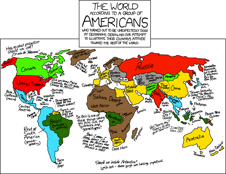
Geographically Adept


From xkcd


Labels: ,

Saturday, December 25, 2010

Christmas Cheer

Cartophiliac and Thatsaabguy wish you plenty of Christmas Cheer and Holiday Beer.


Merry Carto-Christmas:


Labels: ,

Thursday, November 11, 2010

How To Offend The World In One Image

From Thatsaabguy:

This might come in handy for future travel planning...
(seriously, it's a joke, take it as such) :-)


Thanks to these guys!

Labels: ,

Monday, October 18, 2010

The World in Your Morning Coffee

Happy Monday morning. Time for some coffee!

Coffee art, previously on Cartophilia here and here.

From My Food Looks Funny

Labels: , ,

Monday, October 11, 2010

The Man in the High Castle

The Man in the High Castle, by Philip K. Dick, is considered a classic of alternate history fiction. This Hugo Award winning novel is set in a world where the Allies lost World War II; dominated by Nazi Germany, Imperial Japan, and the other pro-fascist nations.

The Guardian reports that Ridley Scott is preparing a BBC miniseries based on the novel. Earlier in his career, Scott had great success adapting Dick's novel of a robotic future, Do Androids Dream of Electric Sheep?, as the film Blade Runner.

To get map lovers in the mood, io9.com offers this map of the world after the fall:


While I always appreciate any attempt to create maps of alternate futures, I found this map maker to be a bit lazy... What? Did Italy fill in the Mediterranean Sea, just so their empire would look bigger?

More Alternate History maps on Cartophilia

HT to Josh Calder

UPDATE: OK, I'm an idiot. Thanks to Ben for pointing out that yes, the Nazis DO actually drain the Mediterranean Sea in this book. I'm a big fan of alternate history, but this is one I haven't read yet. I will correct that deficiency.

Labels: ,

Monday, September 6, 2010

Jello World

Look how the Earth jiggles... would that be like a 100 on the Richter Scale?


From My Food Looks Funny

Labels: ,

Tuesday, July 20, 2010

Yakkos Nations of the World

A while back, Wakko, one of the Animaniacs, taught us all how to remember the State Capitols. Now, here is his brother(?) Yakko to teach us all the names of all the nations on the Earth:


Slower, so you can memorize it:


But don't stop at just the Earth... Learn your way around the Solar System:


... And the Universe!:


Finally, the ultimate authority on The Meaning of Life, Monty Python:


#620

Labels: , ,

Tuesday, July 13, 2010

T-Shirt Tuesday: Beastly Planet

Planet Earth... it's where the wild things are... what's left of them.

In this T-shirt illustration, created by Richard A. Catron, animals are used to to create the continents. Each Beast is native to that part of the world. The Panda represents China, a polar bear in the Arctic, koala in Australia, etc.

(Bear with me here...)

"Beastly Planet" from Threadless Tees

What is T-Shirt Tuesday?

Other map T-shirts on Cartophilia


Labels: ,

Friday, July 2, 2010

Failed States: The Metrics of Decay

The July/August 2010 issue of Foreign Policy is "The Bad Guy" issue... Apparently the "Axis of Evil" has been replaced with "The Committee to Destroy the World." Some of the worst dictators, leading the worst nations of the world.

Included in this issue is the 2010 Failed States Index:
This year's index draws on 90,000 publicly available sources to analyze 177 countries and rate them on 12 metrics of state decay -- from refugee flows to economic implosion, human rights violations to security threats. Taken together, a country's performance on this battery of indicators tells us how stable -- or unstable -- it is.


Holding steady at number one for the third year in a row, the winner and still champion of the failed states, Somalia!

Via Coming Anarchy

Labels: ,

Friday, June 18, 2010

Toilet Seat Maps

Texas artist, Barney Smith, has a museum where he displays more than six hundred examples of his toilet seat art. A master plumber before he retired, he has been creating toilet seat art for 30 years.

At least two of his masterpieces incorporate maps:


Read more about Barney Smith's Toilet Seat Art Museum at RoadsideAmerica.com

View more images of his art at Damn Cool Pics.

Labels: , ,

Friday, June 11, 2010

We Are All BP

We are all BP? Do we all share some responsibility for what has become the Second Worst Oil Spill in History?*

Bullet hole in the Earth by Rangutan88:


Bleeding Bullet Hole XXL by ~Rangutan
Designs & Interfaces / Logos & Logotypes
The BP oil spill in the Gulf of Mexico is a major disaster to nature. It is not only BP that is responsible but ALL those that demand crude oil by using it. If you don't live in the jungle, the Arctic or a deserted island, YOU are guilty too! Give BP a break, hypocrites?
I'm not sure I'm ready to give BP a break just yet... but do we all, as petroleum users, share some of the blame?

*According to The First Post (UK), the worst oil spill in history was:
The Gulf War oil spill. In 1991, retreating Iraqi troops blew up Kuwait's oil wells, leaking up to 11 million barrels of oil into the desert before they could be capped. It would take until June next year for the Macondo well to leak this much oil.
I do think, that an argument could be made, that this is the largest environmental disaster caused by an oil spill...

UPDATE 6/13: I'm surprised no one has called me on that last statement... I have since read of at least one significantly worse environmental oil spill disater; this one in Nigeria. I stand corrected.

Labels:

Saturday, June 5, 2010

Typeset World

Yesterday's NPR report on Lingua Globa: How English Became 'Globish' includes this old style printer's typset map of the world.

#600

Labels:

Friday, June 4, 2010

Mystery Bottle

Mystery Bottle by Kristen Balouch:

A boy in Brooklyn receives a package from Iran. When he opens up the mysterious bottle that lies within, a great wind transports him over the oceans and mountains, straight into the arms of his grandfather. Despite being separated by politics and geography, the boy and his Baba Bazorg can share an extraordinary gift, the bond of their love.


Nearly every page of this delightfully illustrated children's picture book uses maps in the background; from Brooklyn, to the Atlantic Ocean, to Iran.

This book received the 2007 Ezra Jack Keats New Illustrator Award

Labels: , , ,

Saturday, May 1, 2010

May Day! May Day!

May 1.

May Day.

In most nations of the world May Day is celebrated as International Workers' Day or Labour Day. Only two countries do not:


In the United States and Canada, Labor (or Labour) Day is celebrated on the first Monday in September, so as to not be associated with all those REDS on May 1.

Of course, celebrations of May Day date back long before labor movements. Exactly one half year since November 1 means the end of winter weather (for the northern hemisphere) and serves as a call for celebration. Perhaps a romp around the Maypole.
May I make my fond excuses for the lateness of the hour,
but we accept your invitation, and we bring you Beltane's flower.
For the May Day is the great day, sung along the old straight track.
And those who ancient lines did lay will heed the song that calls them back.

In the Society for Creative Anacronism, May 1 is the first day of the new year. Reckoning from the founding of the Society in 1967 C.E., today is the first day of Anno Societatis (A.S.) XLV (45).

"May Day! May Day!" is an internationally recognized distress signal (from the French from the French venez m'aider, meaning "come (and) help me").

HT to Rudolf for the map.

Labels: