Monday, September 29, 2008

Edible Maps

An tasty assortment of edible maps...

An exercise in map symbols from Ms. Welch's Class:


Marzipan Europe from Strange Maps:


A Somalia cake from Ms. Jimenez's Class (watch out for the pirates):


And finally, Catan Cake. An edible version of the boardgame, Settlers of Catan:


MMMmmmmmmmmaps!....

#268

Labels: , , ,

Friday, September 26, 2008

Putin Rears His Head

"As Putin rears his head and comes into the air space of the United States of America, where do they go? It's Alaska." -- Sarah Palin


From the transcript of her interview with Katie Couric on CBS News.

(I don't know who created the image, but I saw it first on BoingBoing.)

P.S. If anyone can point me to a clever use of maps that mock Barack Obama or Joe Biden, I'll be happy to give equal time...

Labels: ,

Survivor: Gabon

My favorite "reality" television program is The Amazing Race, however, my second favorite reality show premiered last night - Survivor: Gabon.

Survivor Maps has gathered some maps of Gabon, and the presumed filming areas:


Or so they claim... could this program actually have been filmed in the forgotten land of Nova Hibernia?

Labels:

Thursday, September 25, 2008

World of Apples

This map of the world is one of many works of art made from thousands of apples at the Apple Festival in Kivik, Sweden.


Via Damn Cool Pics

Labels: ,

Wednesday, September 24, 2008

Buckeye Firsts

Just as Ohio likes to style itself the "Mother of Presidents" (because, like Virginia, they lay claim to eight presidents that called Ohio home), Ohio historians also like to highlight the number of famous inventors from Ohio. The list of famous inventors from Ohio includes Thomas Edison, the Wright Brothers, and Charles Kettering.

I only mention this as an excuse to highlight this poster on display in my library:


The photo does not effectively show the 3-D effect of the state of Ohio thrusting out of the heart of America, but it creates an attractive display.

Labels: ,

Tuesday, September 23, 2008

Paris Map Gift Card

Yet another Live Journal blog in Russian or Ukrainian. As far I can determine, from my Bablefish translation, Konstantin had a co-worker getting married. What to give them? Just cash in an envelope? Not good enough.


The solution: a map of Paris is folded in such a way that it creates a card with a pocket for the cash.

Konstantin's blog title, roughly (babelfish) translated: "I see purpose, I believe in itself, I do not note obstacles!"

Any solution that involves a map is worthy of notice!

Labels: ,

Monday, September 22, 2008

Rugs of the Willing

This blog contains all sort of interesting images from art, posters and advertising from, I am guessing, Russia or Ukraine...

On this page, the blogger has pulled together photos of rugs, including map rugs! Made in Afghanistan? Perhaps these two rugs are marketed to U.S. soldiers, and other particpants in the so-called Coalition of the Willing.


Thanks to Paul at BibliOdyssey

Labels: , ,

Friday, September 19, 2008

Obumper Stickers

The folks at Bumperactive.com, a custom bumper sticker printing company, are offering 52 state-specific (including D.C. and Puerto Rico) Barack Obama campaign bumper stickers. Sadly, only two of them include maps in their design:


In a previous post, I discussed the "mittenmorphic" attributes of the state of Michigan, as well as the old "Say Yes to Michigan" tourism advertising campaign.

Are there any other good examples of the clever use of maps in campaign advertising? Obama or McCain?

Labels: , ,

Wednesday, September 17, 2008

Sporcle: Can you name the most populous US cities?

Can you name the 25 most populous US cities?


Sporcle.com posts new trivia quizzes every day. Many of them are geography related. Today they posted a quiz on the 25 most populous cities in the United States. I am embarrased to say that I only scored 21 out of 25. Can you do better? No cheating by looking at the U.S. Census figures first...

Other map related Sporcle quizzes:

Countries of Europe
Countries of Asia
Most populous cities of the world
etc.

Plus, these were tougher than I thought they'd be:

U.S. State Flags
Flags of Europe

#260

Labels: , ,

Mmmmm... Beer Maps

My favorite Pacific Northwest blogger, Michael5000, sent this photo to me the other day:


"Thought of you on a beer run yesterday -- this is a new (to me, at least) product of Deschutes brewery; the faux topo map on the six-pack carton is a version of the company logo (which you can see on the handle). Reasonably well done, I thought -- a good addition to your collection of carto-marketing?"

A good addition indeed! In fact Mr. 5000 inspired me to seek out further examples of maps on beer. I made a special trip to my favorite beer and wine shop that specializes in designer and craft brews from microbreweries around the country and picked up four six-packs of beer that I had never tried before, based solely on the fact that they included a map in their package design. Its a tough job, but I'm willing to go the extra mile, for you, my carto-friends.

Here are two from Colorado:

This India Pale Ale from Avery features a map of the trade route to India that made the British Empire.

In contrast, this Jackman American Pale Ale from the Left Hand Brewing Company shows what makes America great: Motorcycles! (With a background of a map of western states, including Colorado.)


And two from Bell's Brewery in Michigan.

Bell's Lager of the Lakes features an early explorer's map of the Great Lakes region, while their Third Coast Beer gives us a view of Michigan's upper peninsula and the Keeweenaw Peninsula on Lake Superior and Oceania County on Michigan's Lake Michigan coast. The Great Lakes are often referred to as America's "third coast".


While these beers provide excellent use of maps in their packaging design, they were only fair, if somewhat disappointing in flavor. I cannot recommend cartography as the best criteria for beer selection... but I'm willing to keep trying

Labels: , , , , ,

Tuesday, September 16, 2008

Updated Singles Map

Back in April I posted about The Singles Map of the United States. The map looked at gender population demographics to determine which parts of the country contain more eligible bachelors or more single women.

Jonathan Soma dropped me a line to let you know that he took the idea and ran much much further with it. On this new website you can now control for age as well as population:


Guys and gals, if you're still looking for that special someone, you may need to adjust for your age, and then get thee to the region with better odds! But don't forget the Half-Your-Age-Plus-Seven Rule.


Labels:

Monday, September 15, 2008

The Mouse That Roared

The Mouse that Roared, a 1959 film starring Peter Sellers, based on the book by Leonard Wibberley, tells the story of the tiny, mostly forgotten country of the Duchy of Grand Fenwick.


In the opening segment of the film, the narrator is trying to find the tiny country. Measuring no more than five miles (8 km) long and three miles (5 km) wide, the Duchy and lies in a fold in the Northern Alps, adjacent to France and Switzerland.


In order to resolve a budget deficit, the government of Duchess Gloriana XIII decides to declare war on the United States. They expect to lose of course, but expect their defeat to be followed by millions of dollars in foreign aid.


When the declaration of war is ignored, they send an invasion force to New York.


The filmmakers intersperse the scenes of this journey with map animations of their misadventures at sea. I just had some fun clipping these stills out of the video.


Without rehashing the entire plot, instead of losing, as ordered, the expiditionary force wins the war! Hilarity ensues. While not a map, this scene late in the film also caught my fancy. Regular readers of this blog know of my love for boardgames, so I was tickled by this scene where diplomats from Britain, France, the USSR and the United States, while waiting to cross the border, kill time by playing a boardgame:


The Mouse That Roared is an amusing little farce that showcases Peter Sellers understated comedic talent. Recommended.

Labels: , , ,

Friday, September 12, 2008

Harry-est Town in America

This news is a bit "last year"... but it is the first time I heard of it, and I like the graphic... From Amazon.com:


The Harry-est Town in America


After months of tracking pre-orders of Harry Potter and the Deathly Hallows, Amazon.com can now reveal the Harry-est town in the country: Falls Church, VA! Residents of Falls Church ordered more copies of Harry Potter and the Deathly Hallows from Amazon.com per capita than any other town in America. As a result of Falls Church's "Harry-ness," Amazon.com is donating a $5,000 Amazon.com gift certificate to The Mary Riley Styles Public Library Foundation Trust of Falls Church.

Falls Church beat out Gig Harbor, WA, and two other Virginia towns--including Fairfax and Vienna--with Katy, TX, rounding out the top five. Media, PA, Issaquah, WA, Snohomish, WA, Doylestown, PA, and Fairport, NY, completed the top ten Harry-est Towns.

Amazon.com used the most recent U.S. Census data and included all U.S. towns and cities with a population of more than 5,000 people.

Labels: ,

Thursday, September 11, 2008

9/11Maps

The University of Texas Perry-Castañeda Library offers many of their maps online. In addition, they have compiled lists of maps on other sites by topic. In honor of today's sad anniversary; Maps Relating to September 11, 2001 and Later Events:


This map was produced by the New York City Department of Buildings to give a general of overview of damage done to buildings near the World Trade Center, as introduced in the Moussaoui trial.

Labels:

Wednesday, September 10, 2008

Big Apple, or Big Spud?


From Very Small Array, via Curbed.com

Two really cool mappish/design/architecture/popular culture/etc. and other stuff blogs I've just discoverd.

Labels: , , , , , , ,

Tuesday, September 9, 2008

Korea At Night

Fifty years ago today, the Korean peninsula was formally divided into North and South. How's that been working out for them? Below is a satellite image of the peninsula at night... I'm sure the North Korean astronomers, when they can drag themselves from their starvation stupor to look into their telescopes, get a terrific view of the stars without all that light pollution...


From the National Geographic Map of the Day.

Thanks, Marilyn.

#253


Labels: , ,

Play With Spider

Play With Spider: "An experimental project to make a natural spider in Flash, combining math and graphics."


While it is fun to watch the spider clean up all the dead flies, I am distracted by the 15th century map of Europe.

Via Boing Boing

Labels:

Monday, September 8, 2008

Tenochtitlan

While I was in Mexico recently, I looked for map postcards, but only found a few. Here are two focusing on Mexico and Mexico City before the Spanish conquest.

Mexico City, or Tenochtitlan, was the capital city of the Aztec civilization. The city was centered around the main temple, the Templo Mayor.


The remnants of the temple have been excavated (circled in red) in what is still the center of Mexico City today:


It is hard to imagine that where this modern city sits was once a large lake.


Of course, the Aztecs were just one of many mesoamerican civilizations


Labels: ,

Saturday, September 6, 2008

Football TV Coverage Maps

College football has been under way for a week, and NFL football started on Thursday night. All is as it should be in the universe... except that sometimes, you cannot watch your game of choice... Which college or NFL game is going to be shown in your market?

ESPN offers coverage maps of the games their channels and partner network ABC offer:


The Map Room has alerted me to the excellent NFL TV coverage maps on the506.com that now make use of Google Maps technology:


I am often frustrated by the choices that the networks make, to decide which games I get to see in my town. Naturally, being very close to Cincinnati, we always get the Bengals games, however, there are a great many Cleveland Browns fans in this area. Their families have been Browns fans since long before the Bengals were in Ohio. So, not too surprisingly, we will get Browns games, when they don't conflict with a Bengals game. The next nearest football markets are Indianapolis, Detroit and Pittsburgh. So why do they keep showing us Dallas Cowboys games? I hate the Cowboys. They call themselves "America's Team" but they have never been my team. The networks like to assume everyone in Ohio gives a flying frak. In my opinion, Dallas Cowboys fans that don't live, or have some connection to the Southwest, are all just a bunch of bandwagoners. Even Adolph Hitler was a Cowboys fan!

End of football rant.

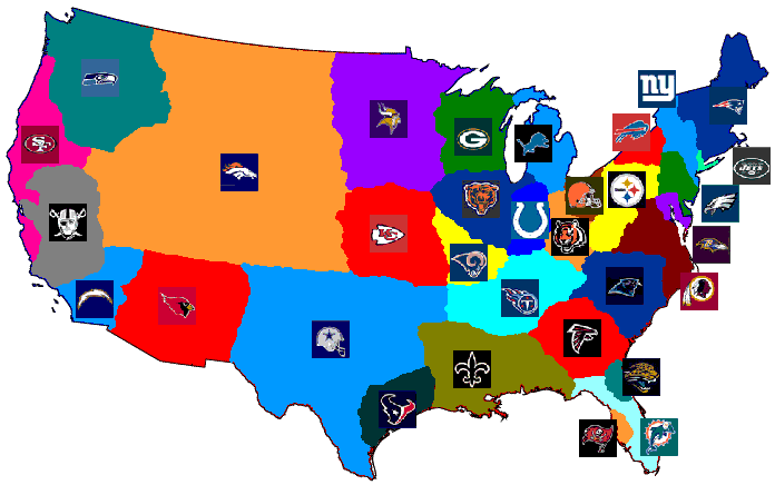
This division of the United States by perceived interest in a specific football team only reminds me of my own United Countries of Football map (shameless plug):

Labels: ,

Friday, September 5, 2008

Tepoztlán

On my first full day in Mexico last month, Mrs. Cartophiliac took me to the little touristy town of Tepoztlán.


The highlight, literally high, was our climb up the steps on the side of a mountain to see the Tepozteco Pyramid.


The Tepozteco is thought to have been built in the early Aztec era (AD 1100-1350). The structure is dedicated to Ometochtli-Tepoxtécatl, god of pulque (a drink made of fermented maguey native to Mexico), fertility and harvest, and carvings depict offerings and sacrifices to the deity.


To reach the site, you must climb a trail that leads off the end of the main street, the climb takes over an hour. The climb is steep and arduous. The pyramid is about 1320 ft. above the base of the valley, starting at over 6000 ft. of altitude.

Mrs. Cartophiliac and I agreed that the climb was one of, if not the most physically challenging things we have ever done. My heart was beating like a bongo drum and I was often short of breath. However, we passed dozens of little old ladies with canes, on their way up or coming down. We figured if they could do it, we could. The climb was worth the effort. The view was spectacular It is possible see the whole town of Tepoztlán from the top of the mountain.

Labels: ,

Thursday, September 4, 2008

Blogiversary: A Year of Maps and Map Memorabilia

Today is the First Anniversary of Cartophilia. The very first post on this blog was September 4, 2007. At the time, I wasn't sure what exactly this blog was going to be about. I had a vague notion that I was going to highlight my own small collection of map memorabilia... but then what?

As it turns out, I have only scratched the surface on my own collection, the map postcards, ads, book covers, etc., that I had collected over the years before 2007. Instead, I found a wealth of other map blogs out there to highlight, I discovered that there were far more examples of maps as art than I ever imagined, and political maps and flags and imaginary countries are just kind of fun!

Quastolia:


When I look at my stats, I see that most of the traffic is driven here by Google Images; not too surprising, since this this blog is more about mappish images than anything I write (which is usually boring). As near as I can tell, one of the most, if not THE most popular page on this blog, is my post about the United Countries of Football:


Football season is back, so maybe I'll revisit this topic...

I appear to have a following... I can see that people are reading and returning to this blog, even though I don't get many comments. I'm surprised that I have kept this up... often I start something "creative" and it peters out quickly from lack of interest or momentum. However, I don't anticipate ever running out of interesting or fun examples of maps, map memorabilia, and maps used in design and art. So, as long as it appears someone is looking from time to time, I imagine I'll stick with it.

#248

Labels: