Sunday, January 9, 2011

Yet another URL

I have become fed up with my web hosting service. I no longer recommend Lunarpages.

So, I'm moving this blog so that it is solely on blogspot. The new url for this blog is will be http://cartophilia.blogspot.com/

Most of my images may disappear from here for a while, but I expect to get most of them back up soon. It may take a few weeks. But then, its not like I've been posting a lot lately anyway.

Please stand by.

#715

Labels: ,

Wednesday, October 6, 2010

Online Geography 2010

The UberGeek web comic, xkcd, has updated its map of online communities from 2007:


Click image to see hi-res


Online geography changes much more quickly that earthly geography.

Where is Cartophilia in all this? Somewhere in the Miscellanea I suppose...


Other xkcd maps featured on Cartophilia

HT to BillWendel

Labels: , ,

Thursday, August 26, 2010

Welcome to Guest Blogger and The Ten Cent Maps

Today I would like to introduce Phil (posting as "Thatsaabguy", a long time carto-fan of Cartophilia. If you look at my posts over the last year, you will see that in many of them I gave a HT (hat tip) to Phil for pointing out to me this or that amusing or interesting little map thing. Since my frequency of posting has decreased lately, I thought it might spice things up if we included some input from other map lovers.

To start things off, here is a little story of his. Soon, he'll post his own stories about his map fetishes and geographic adventures.
Howdy folks! Thanks to Cartophiliac for allowing me access to his precious, I shall do my level best to not let him down! It’s weird – Cartophiliac and I SHOULD have met each other many times over, as we have mutual friends, play similar board games, both live or lived in Dayton, and both have an unhealthy map fetish. Thanks to the power of the interwebs, however, we’ve hooked up and will be bringing you double the mappy goodness!

Just to show you how deep is my obsession, here’s a true tale from this past weekend. I was garage-saleing with my wife (whose Mapkini has been featured in these very hallowed pages) and came across a small box labeled “MAPS 10¢”. When I naturally asked about them, the nice lady explained they were a collection of National Geographic maps from “I dunno, starting sometime in the 1960s is all I know. You can have the entire box for A DOLLAR.”

That’s right, one crisp American dollar.

I cannot begin to describe my squeals of joy. Upon further inspection, the box weighed a good 20 pounds, and was essentially a solid brick of mappy love. As you can see, it covers my dining room table to a thickness of about two inches. I haven’t catalogued them yet, but I’m half tempted to just wallpaper a room with them and get it over with.


#635

Labels: ,

Tuesday, August 24, 2010

Map Quilt Art?

Regretsy is the website that highlights less than stellar art to be found on Etsy, the sell-it-yourself arts and craft website. Regretsy has become such a popular site, sometimes I wonder if people intentionally create regretful art in hopes of being featured there... Intentional, ironic, satiric or serious, this one cannot be ignored:


These United States of America
by the seller "muddlefoot".

Titled "Continental Drift" on Regretsy.

Via The Map Room

UPDATE 8/25: Geography blogger, "kuschk", has solved the mystery of the quilt... it is a cartogram!


More images and commentary at his new blog The Basement Geographer

"kuschk" describes himself as an, "Obsessive-compulsive geographer with a morbid sense of humour that I try and keep out of my blog." I'll be adding this one to the list of blogs I follow.

Labels: , ,

Thursday, June 10, 2010

Vexillophilia and Ausflag

Yours truly, Cartophiliac, loves maps. It's in my name. Many times, while discussing maps, I find an excuse to also mention flags. [Flags on Cartophilia]. For example, when creating and drawing maps of imaginary countries, it is often necessary to create flags for these imaginary countries. [See Flag of Quastolia.] It is time to come out of the closet. In addition to being a Cartophiliac, I am also a Vexillophiliac. A flag lover. [See Vexillophile]

So, fellow cartophiles, if you care to join us, I have begun a new blog project: Vexillophilia: Flags and Flag Fun. In this new venture, I have been joined by Michael5000, my favorite blogger from Portland, OR, and fellow cartophile and vexillophile. Michael and I have already written about flags in history, flag days, flag songs, and Michael has undertaken to give a letter grade to every national flag of the world (à la Josh Parsons).

Today, Michael5000 wrote about The Great Australian Flag Debate describing the movement in Australia to replace its Union-Jacked flag with something more... "local".

"Ausflag is an apolitical, non-profit organisation seeking to secure the popular support of the Australian people for the adoption of a truly Australian flag."

What I love about this logo is that instead of a flag with a map on it... it is a flag, that looks like a map! (See, I eventually came back to maps.)

Good luck, Australia, I'll love your flag, whatever you decide...

Labels: , ,

Wednesday, April 28, 2010

Comic Book Cartography

The map blog Comic Book Cartography gathers images of maps, schematics and cut-away diagrams from classic comic books.

The Fantastic Four at war with Namor the Sub-mariner?


Hemispheric Maps of Superman's home planet, Krypton:


The East Coast according to DC...


OMG! Superman's Metropolis is in Delaware? Batman's Gotham City is just across the bay in in New Jersey? Who knew?

For more Comic Cartography, check out Atlas of the DC Universe.

Labels: , , , , ,

Monday, January 11, 2010

MapMarks Transit Blog

This week is Transit Map Theme Week at Cartophilia!

In the last several weeks I have either happened across, or had links to interesting transit maps sent my way. So many in fact, I don't want to cram them all in to one post.

Today, I will introduce you to a new blog by Transit Map maven, Mark Ovenden: MapMarks. Mark promises to share with us about "maps, metro's, cartography, transport and a handful of other nonsense."

Mark Ovenden is the author of two recent books on transit maps:

Transit Maps: The World's First Collection of Every Urban Train Map on Earth
Paris Underground: The Maps, Stations, and Design of the Metro

UPDATE 1/12: This book just got a
review in the NewYorker.
Via The Map Room


Labels: , , ,

Wednesday, November 11, 2009

Give the Gift of Map Books

The holiday shopping season is rapidly approaching. Here are two recently published books of interest to that cartophile on your shopping list:

The Map as Art: Contemporary Artists Explore Cartography by Katharine Harmon

In a sequel, of sorts, to her previous book on map art, You Are Here: Personal Geographies and Other Maps of the Imagination, Harmon promises to lead her readers to:
different destinations: places turned upside down or inside out, territories riddled with marks understood only by their maker, realms connected more to the interior mind than to the exterior world. These are the places of artists' maps, that happy combination of information and illusion that flourishes in basement studios and downtown galleries alike.
You Are Here featured previously on Cartophilia:
Happy Father's Day to Me
On the Road to...?
Be My Cartographic Valentine

Strange Maps: An Atlas of Cartographic Curiosities by Frank Jacobs

Jacobs has been publishing his hugely popular Strange Maps blog since 2006, where he "collects and comments on all kinds of cartographic curiosa". As has become a blogger custom lately, he has collected over one hundred of his strangest maps into this handsome soft cover coffee table book. Includes his extensive commentary.

UPDATE 11/13: The Freakonomics blog has an interview with Frank Jacobs (HT to The Map Room).

Interestingly, both books feature upside-down/inside-out maps on their covers.

Tell them Cartophilia sent you.

#495

Labels: , ,

Tuesday, October 13, 2009

Happy Blogiversary!

Happy Second Birthday to TheElectoralMap.com! My favorite political geography blog.

Reading about Patrick's anniversary reminds me that I completely forgot to note my own second anniversary last month: September 4. (Perhaps because September 4 is also the anniversary of a failed marriage, it remains obscured in my mind.)

Last year, I noted my first blogiversary here. Perhaps I'll do something special for post #500 which should be coming up soon...

This is post #480

Labels:

Tuesday, September 15, 2009

Cartocacoethes

Steve, the best maintenance man ever employed by my library, is currently repainting my department. The walls in this room have not been painted since the department was created, nearly twenty years ago. That dark red, dark blue and grey have always seemed a bit gloomy and we are being cheered by the fresh shades of blue and green on our walls. First, he works around the trim before attacking the larger areas with the roller... but wait! Is that a map of Ohio I see?


Cartocacoethes is a word coined to describe "a mania, uncontrollable urge, compulsion or itch to see maps everywhere." Yeah, that sounds like me.

I don't know if it is a real word. I cannot find it in the Oxford English Dictionary. The only reference I can find to it is on other map blogs, and has been discussed, at length, on Making Maps and Strange Maps. If someone has a citation to an actual medical dictionary reference to this word, please send it my way.

UPDATE:
jb krygier said...

Of course it is a real word, I know because I made it up. I was reading up on the Catalhoyuk map and working on an essay with Denis W. about the actual absence of maps prior to 1500 (very few and far between) and it dawned on me that most "prehistoric maps" are not really maps, and there is a mania among modern cartographic historians (and others) to cast our modern sense of mapping back into prehistory, to prove maps have always been with us. Anyhow, the Catal. map is a prime example of seeing maps where there are none, and it is not just a passive thing, but an active mania. So cacoethes made sense, and carto tagged onto it led to a word that sounded like it should exist, so there you are.

Labels: , , ,

Wednesday, September 9, 2009

Gnomes of North America via Mexico!

Cartophilia, the love of maps, is universal and international.

Recently discovered: ¡Mapas, mapas! a Spanish language map blog by Fernando Augusto López Plascencia of Mexico.

What map has caught Fernando's eye? Gnomes of North America:


In particular, the Gnomes of Frankenmuth, Michigan. Frankenmuth is famous throughout Michigan for its year-round Christmas themed shopping and "family-style" chicken dinners. We used to go there every year when I was younger, but no one ever told me about the Gnomes...

I guess they are secret no more...

#465

Labels: ,

Thursday, June 11, 2009

Daytonology North

Last month, in a post about Lost Highways, I wrote about the National Road and the Dixie Highway as part of the national road system prior to the numbered U.S. Highways and Interstates.

The Daytonology blog has posted a brief history of transportation routes north from Dayton as part of a series of articles discussing development of Vandalia and other points North.

Maps include rivers, canals, railroads and highways.

Labels: , ,

Friday, May 8, 2009

A Rebel in Siam

Showing off the latest addition to my map postcard collection:


It's not very clear what year this antique map was made, but no matter. It shows parts of what is now Thailand, Cambodia, Vietnam, Laos, Malaysia, Indonesia, Burma and China. All areas underrepresented in my collection.

It was sent to me by "Rebel", an American (or Aussie?) blogging from Thailand: Rebel's Work In Progress - Thailand Edition!
After spending my post-college decade stuck in unfulfilling office jobs, I decided to strike out and see the world. First stop - Thailand.

Thanks, Rebel, for pausing to send this postcard!

UPDATE 5/14: Rebel tells me that she is "American as apple pie... you know the kind you get in a little cardboard box at McDonalds. ;)"

Labels: , , ,

Thursday, May 7, 2009

The YouTube River flows into the Google Ocean

Article today on Techcrunch.com about how Google will incorporate YouTube into it's new social networking initiatives.

YouTube River Diverted Into The Google Social Ocean As Well, accompanied by this metaphorical graphic:

Can anyone identify the location of this satellite image?

HT to Hunter

Labels: ,

Tuesday, April 7, 2009

Manhattan Euro

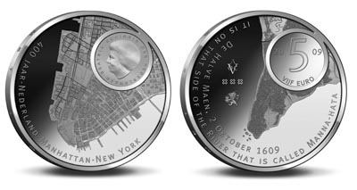
This morning I highlighted the fictitious Amero coin with a map on it. Then this evening, on the Cartografie Twitter feed I saw a link to a real coin, the Dutch Euro, featuring the island of Manhattan:


According the to the Dutch map blog, Studiekring Historische Cartografie, The Netherlands has issued a 5 Euro coin commemorating the 400th anniversary Henry Hudson's discovery of the island of Manhattan, soon to be the city of New Amsterdam, later New York. (Why'd they change it? I can't say. Maybe they like it better that way.)

My best understanding of the Dutch text, using an online translator: The front shows, along with an inset of Queen Beatrix, the exact structures of Manhattan anno 2009. The artist has given the coin a 3D impression of of Southern Manhattan. The back of the coin has the landscape of Manhattan anno 1609, accurately reflected thanks to scientific research of the Wildlife Conservation society in New York.

To my Dutch readers, please feel free to tell me more!

Studiekring Historische Cartografie is another great map blog. The love of maps is universal!

UPDATE 4/8: I knew I could count on the friendly Dutch people to help me out. Here is a link to the English translation

Labels: , ,

Tuesday, March 31, 2009

2008: The Year in Political Geography

Patrick Ottenhoff's political geography blog, The Electoral Map, was my favorite site this past year for electoral maps, county voting projections, and interesting commentary.

Here, he has pulled together a mappish Year in Review for 2008:


Labels: , , ,

Tuesday, February 10, 2009

The Map Scroll

The Map Scroll is a new map blog (January 2009) with an emphatic Mission Statement: "You know what you need? A blog that updates with one new bitchin map every goddamn day." The blog's author, "Chachy B. Terwilliger", is doing just that. Every day he has posted a map, some I've seen before, some new; but each of them has been interesting. For instance:

The Greatest Journeys Ever:


The Skin Color Map:


and the Place of the Week: Pitcairn Islands


I admire Chachy's persistence. It will be interesting to see how long he can keep up the pace... but one way or the other I look forward to his next post.

Labels: ,

Friday, January 30, 2009

Hand Drawn Map Contest


The Hand Drawn Map Association will be publishing a collection of hand drawn maps with the Princeton Architectural Press. To celebrate and help collect interesting maps for possible inclusion in our upcoming book, they will be running a contest over the next few months.

Submit a hand drawn map to the Association before April 30, 2009, and you may win a "super-limited edition monoprint".

Labels: ,

Tuesday, January 13, 2009

I'm a Twit

So, I recently wrote about (and mocked) the whole Twitter thing. However, enough folks out there assure me it is really cool and fun... so, I'm going to give it a try. If you other Twits out there want to follow my Tweets (I can't believe I'm even writing this) my feed is available at: http://twitter.com/cartophilia.

In addition, for those of you wasting time like me on Facebook, I have joined Networked Blogs and you can follow my blog there as well.

Hope you all enjoy it.

Knock yerself out.


Labels: ,

Friday, December 5, 2008

America Deflated

Often I have highlighted a map that provides an "inflated view" of its subject. In other words, making it appear larger (and by inference, more important).

Artist Nina Katchadourian has taken an opposite approach. She has taken a standard AAA road map of the United States and "deflated" it, to only include the portions that are relevant to her life:

Coastal Merger:
I was born in California, moved to the east coast for college, went back to the west coast for graduate school, and now live on the east coast again. This map reflects my bicoastal experience of this country.
From a purely technical point of view, I am impressed with the way she carefully matched up coastlines and highways to create a seamless merger. I wish I could get a closer look.

Katchadourian's work can also be seen in this collection, Opener 11: Nina Katchadourian: All Forms of Attraction and in my favorite "maps as art" book, You Are Here: Personal Geographies and Other Maps of the Imagination by Katharine Harmon.

Via Creative Mapping: "A blog dedicated to the creative use of maps in art or how to map information creatively. All in all we are dedicated to showing map art."

Labels: , ,