Friday, August 27, 2010

The Rap Map

From Thatsaabguy:

Under even the best of circumstances, I'm not a fan of hip-hop music. You'd never guess this by my ability to quote the movie "Friday" almost verbatim, nor my recent fascination with the Boondocks cartoon on Adult Swim...but pay no attention to the crazy man.


What we have here is The Rap Map, a lovingly compiled page that catalogues all manner of hip-hop locations in numerous American cities. These locations are sometimes historically important to the genre (such as Mos Def's Childhood Home and Eminem's alma mater, Osborn High School), sometimes mentioned in songs ("Glock-Glock" and a Home Depot parking lot), sometimes apropos of nothing at all (the Folsom Street Fair).

In almost every case, the descriptions given in these links are NSFW, but what did you expect from a catalogue of all things hip-hop? If nothing else, it's a cool use of Google Maps!

Don't worry, next time I'll post something slightly less shocking, I promise...

Labels: , ,

Tuesday, August 10, 2010

T-Shirt Tuesday: Reach For The Sky

This T-Shirt, with a New York City theme, was designed by Alan Segama. Featuring Lower Manhattan and The Battery, this graphic highlights transit routes below the city, city streets and the city skyline.

Reach For The Sky.

"Reach For The Sky" from Threadless Tees

What is T-Shirt Tuesday?

Other map T-shirts on Cartophilia


Labels: ,

Wednesday, April 28, 2010

Comic Book Cartography

The map blog Comic Book Cartography gathers images of maps, schematics and cut-away diagrams from classic comic books.

The Fantastic Four at war with Namor the Sub-mariner?


Hemispheric Maps of Superman's home planet, Krypton:


The East Coast according to DC...


OMG! Superman's Metropolis is in Delaware? Batman's Gotham City is just across the bay in in New Jersey? Who knew?

For more Comic Cartography, check out Atlas of the DC Universe.

Labels: , , , , ,

Friday, March 5, 2010

New York City in Legos

Christoph Niemann’s illustrations have appeared on the covers of The New Yorker, Atlantic Monthly, The New York Times Magazine and American Illustration. His newest book, I LEGO N.Y., shows us another view of New York, with Legos, including maps:


His project started during the cold and dark Berlin winter days...


Labels:

Tuesday, January 12, 2010

New York City Subway Map Fabric

I'm catching up on fun maps during Transit Map Theme Week here at Cartophilia.

The City Quilter of New York City "specializes in fabric for the urban quilter and sewer" (oh, sew-er, I had to re-read that before I understood they weren't talking about the underground sanitary system...) including New York themed fabric patterns like this:


The New York City Subway System is available in three backgrounds (white, beige and black).


Other New York City themed fabrics; taxis and the New York Times:


Via The Map Room


Labels: ,

Monday, August 31, 2009

Smells of New York

New York Times: Scents and the City By Jason Logan. An interactive map of the smells of New York:

New York secretes its fullest range of smells in the summer; disgusting or enticing, delicate or overpowering, they are liberated by the heat. So one sweltering weekend, I set out to navigate the city by nose...
Fortunately, for all of us, they have not yet perfected Internet smell-o-vision...

HT to Gwen

#460


Labels:

Sunday, August 16, 2009

New York Pops Up

An excellent info-graphic that uses a "3-D" effect to portray population. In this case, it contrasts the population shift that goes on in New York City (a portion of Manhattan, to be specific) between day and night. The bars showing relative numbers looks like a stratospheric city skyline:


I got a chuckle when my imagination created the image of a city with massive towers that rise out of the ground as workers arrive in the morning, and recess in the evening as all the workers go home. No need for elevators!

Via The Urbanophile

Labels: ,

Thursday, June 18, 2009

Henry Hudson 400

2009 marks the 400th anniversary of explorer Henry Hudson's voyage to what is now New York City. His exploration up the Hudson River laid the claim for the Dutch colony of New Netherland and the town of New Amsterdam.

The Henry Hudson 400 Foundation, a joint effort by New York and Amsterdam, has created a bilingual website to commemorate the event, including an interactive map to retrace Hudson's famous voyages:


Previously on Cartophilia: Manhattan Euro

Labels: ,

Friday, May 15, 2009

3-D Aerial View of Manhattan


Beautiful aerial view of Manhattan in 3-D from Pixelcase. Zoom in and rotate, along with spacey music.

Via Kelso’s Corner

#390


Labels:

Monday, May 4, 2009

Ringworld Manhattan

Several people sent this one to me:

Here & There is a map of Manhattan looking uptown from 3rd and 7th, and downtown from 3rd and 35th. It puts the viewer simultaneously above the city and in it where she stands, both looking down and looking forward.


Of course, science fiction fans immediately think of Arthur C. Clarke's Rendezvous with Rama:


and Larry Niven's Ringworld:


Television's Babylon 5 also took place inside a circular space station:


and video game fans can't help but think of Halo (a blatant rip-off of Ringworld):


Labels: , ,

Tuesday, April 7, 2009

Manhattan Euro

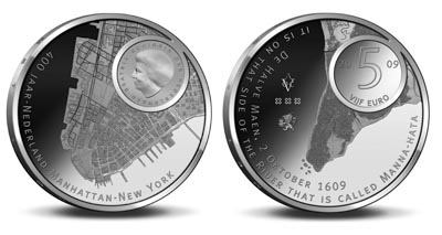
This morning I highlighted the fictitious Amero coin with a map on it. Then this evening, on the Cartografie Twitter feed I saw a link to a real coin, the Dutch Euro, featuring the island of Manhattan:


According the to the Dutch map blog, Studiekring Historische Cartografie, The Netherlands has issued a 5 Euro coin commemorating the 400th anniversary Henry Hudson's discovery of the island of Manhattan, soon to be the city of New Amsterdam, later New York. (Why'd they change it? I can't say. Maybe they like it better that way.)

My best understanding of the Dutch text, using an online translator: The front shows, along with an inset of Queen Beatrix, the exact structures of Manhattan anno 2009. The artist has given the coin a 3D impression of of Southern Manhattan. The back of the coin has the landscape of Manhattan anno 1609, accurately reflected thanks to scientific research of the Wildlife Conservation society in New York.

To my Dutch readers, please feel free to tell me more!

Studiekring Historische Cartografie is another great map blog. The love of maps is universal!

UPDATE 4/8: I knew I could count on the friendly Dutch people to help me out. Here is a link to the English translation

Labels: , ,

Thursday, March 26, 2009

Sitcom Maps

What was the fictional locale of your favorite TV sitcom? New York City? Milwaukee? Reno? Cocoa Beach?

Dan Meth, as a part of his series of Popular Culture Charts will help you find them on his U.S.A. Sitcom Map:


There are, of course, a disproportionate number of sitcoms that take place in New York City (although they were probably filmed in Hollywood, California):


I'm guessing that perhaps chart #5 will be a map of Southern California?

UPDATE 4/7: UK TV Series Map at meish.org

Labels: ,

Thursday, December 18, 2008

Mapping Rats

From Time Magazine online: Mapping the Rats in New York City, by Christine Gorman.
Michael Mills, a veteran health inspector in New York City, helps create a map of the city you won't find in any guidebook: a rat map. That's right, a map of the New York neighborhoods that rodent populations call home.

The city's rat map was first introduced a year ago, with an intensive pilot program in the Bronx. Mills and other inspectors scoured the streets, building by building, cataloging rat hot spots — places that show so-called active rat signs, such as lived-in burrows, fresh droppings, telltale gnaw marks on plastic garbage bags — in an effort to target rodent-control measures more effectively. That geocoding information was entered into each inspector's handheld indexing computer and aggregated with similar data from all across the borough.


The New York City Department of Health and Hygiene provides a Rat Information Portal. From there you can pull up the Rat Map and retrieve rat data by borough, community district, zip code, or specific address.

Note the cute little rat icon that pops up when updating the map.

The most interesting book I have read on rats... OK, really the only book I have ever read on rats, is Rats: Observations on the History and Habitat of the City's Most Unwanted Inhabitants by Robert Sullivan. I enjoyed reading this book, and not just because of the great map cover:


Sullivan provides a compact history of rats in North America, but focuses primarily on New York City. His "field studies" include spending weeks in alleys observing the daily life of rats, and riding with "pest control technicians".

Publishers Weekly said, "Like any true New Yorker, Sullivan is able to convey simultaneously the feelings of disgust and awe that most city dwellers have for the scurrying masses that live among them."

HT to La Gringissima for the Time article.

Labels: ,

Monday, November 17, 2008

Map Shoes Go Swoosh!... and Splash!

Rex Parker, crossword puzzle solver and vintage paperback book collector, sent to me this photo of a map on a Nike shoe:


That prompted me to seek out more info... instead, what I found were additional examples of maps on Nike shoes.


From MyFirstAirShoes.com:


From SlamJump.com.


See previous examples of map shoes:

The Tennessee Representa and Jennifer Collier's map shoe sculpture.

Also, while searching for map shoe information, I was reminded of this amusing, yet environmentally tragic story the cargo ship full of Nike products that accidentally dumped in the North Pacific back in 1999. Shoes and other flotsam were washing up on British Columbian beaches for years.

More recently, there have been grisly stories of Nike (and other) shoes, with feet still in them, washing up in BC.

Labels: , , ,

Thursday, September 11, 2008

9/11Maps

The University of Texas Perry-Castañeda Library offers many of their maps online. In addition, they have compiled lists of maps on other sites by topic. In honor of today's sad anniversary; Maps Relating to September 11, 2001 and Later Events:


This map was produced by the New York City Department of Buildings to give a general of overview of damage done to buildings near the World Trade Center, as introduced in the Moussaoui trial.

Labels:

Wednesday, September 10, 2008

Big Apple, or Big Spud?


From Very Small Array, via Curbed.com

Two really cool mappish/design/architecture/popular culture/etc. and other stuff blogs I've just discoverd.

Labels: , , , , , , ,

Tuesday, July 1, 2008

Maps On The Brain

A selection of recent publications with maps on the cover:

A book:

The Political Mind: Why You Can't Understand 21st-Century American Politics with an 18th-Century Brain by George Lakoff

The author attempts to explain why a great number of Americans actually vote against their own interests.


Some magazines:


The cover of this issue of The New Yorker (June 23, 2008) features cover art, “Summer Job”, by Bruce McCall.

If you cannot make out the detail, it fancifully depicts bears checking in and out of the "Employees Entrance" at a National Park, while the tourist are reminded, "No picnicing in Buffalo Wallows."

If you look very closely, you can see that, yes indeed, there is a map! A "You Are Here" map of the park for the tourists.

This cover reminds me of the old Warner Brothers Cartoon where Ralph the wolf and Sam the sheepdog clock in, as buddies, before battling over the sheep.


“Subway Man”, by Roz Chast, graces the June 30 issue of The New Yorker. A stressed out commuter IS the transit map of Manhattan.

Finally, the June 21, 2008, issue of the New Scientist magazine features a very hot looking planet Earth, for a cover story on global warming.


#207

Labels: , , , , , ,

Friday, June 13, 2008

Manhattan Rose to the Occasion

Aware that the Island of Manhattan has lately been taking a holday... Michael5000 noticed a special visitor at the Portland Rose Festival:


#194

Labels: , ,

Friday, May 30, 2008

Flight of Manhattan

Fun with MapQuest and Google Maps.

First it was Bill Renken's Errant Isle of Manhattan, on Radical Cartography: "What would happen if Manhattan itself decided to take a tour of the oceans, stopping at other cities to refuel and have a good time."

First stop: Chicago


Jason Kottke speculates on a visit to San Francisco


Seth Holladay takes the island to Boston


However, the first thing I thought of, after viewing these fantastical maps, was the series of science fiction books by James Blish; Cities in Flight. Centuries into the future, the invention of massive antigravity devices allow entire cities, including New York, to get up and leave the planet. These "Okies", as they come to be known, struggle to get by as they offer their services to less industrialized planets.


UPDATE 6/10: Just came across this entry in the Worth1000.com B2B: Miniature Worlds contest: Colony City By funkwood


Labels: , ,

Saturday, April 5, 2008

Map Impact

I am already a big fan of Worth 1000, an image manipulation contest site. It is always fun to browse their galleries and see what these PhotoShop wizards will create next. Of course, this image is my current favorite:


This entry, Map Impact, by "doehlman" was entered in the Liquid Assets 8 contest: "For this contest, you should swap any liquid with another object."

Creator Comments: A strawberry hits the big apple

Labels: ,